


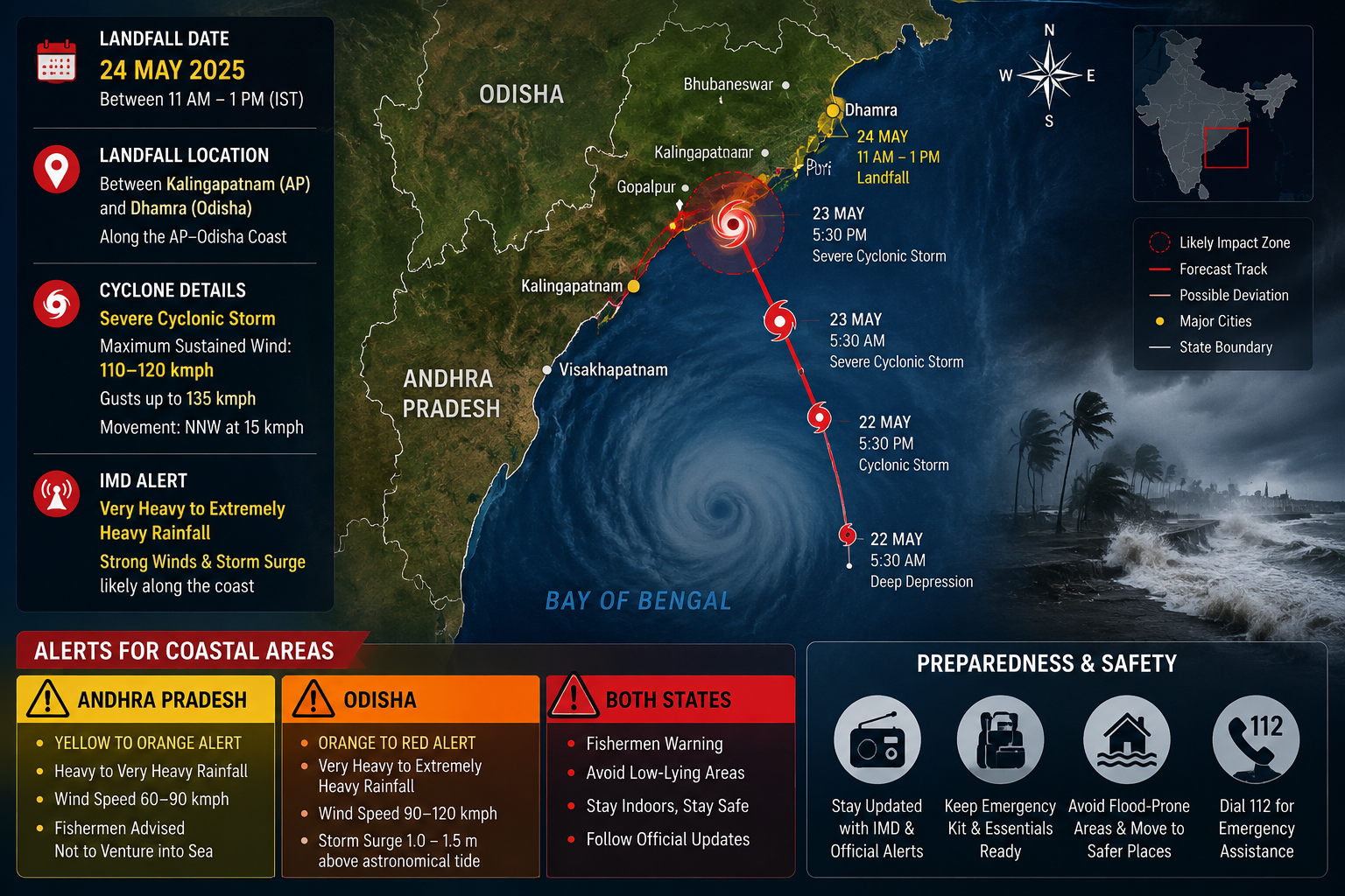
Cyclone Akvan is heading for the Andhra Pradesh coast, and the India Meteorological Department (IMD) expects it to cross land around noon on Friday, 20 November, as a very severe cyclonic storm. Wind speeds of 120 to 130 kmph are forecast at landfall, with gusts of up to 145 kmph.
The system is now over the Bay of Bengal, and states along the east coast have started getting ready. Odisha has put 74 rescue teams in place and begun moving people out of vulnerable areas. Fishing harbours in north Andhra have been told to stop operations. Rain alerts have also gone out for Telangana, Tamil Nadu, Puducherry and parts of West Bengal.
This is the third cyclone to affect Andhra Pradesh in a few weeks, after Cyclones Arnab and Murasu. This report covers where Akvan stands today, the expected landfall time and path, the alerts by state, what the administration is doing, and what residents should do before the storm arrives.
Cyclone Akvan Latest Update: Where the Storm Stands on 17 November
As per the IMD bulletin issued at 2:30 am on Tuesday, Akvan stayed practically stationary over the Bay of Bengal for nine hours overnight. The pause was not a sign of weakening. The IMD expects the system to become a severe cyclonic storm by Tuesday evening and a very severe cyclonic storm by the morning of 19 November.
The storm is moving north-northwestwards. Forecasters expect it to bypass Tamil Nadu and head towards the Andhra Pradesh coast around 19 November. A Hindi report from Patrika quoted the weather department as saying the calm was temporary and that the storm could pick up dangerous speed within 48 hours.
One thing to note is that the landfall timing has shifted. Some earlier reports spoke of the night of 19 November. The IMD’s latest update points to noon on 20 November, and that is the timing to use.
Cyclone Akvan Landfall Date, Time and Path
The IMD says Akvan is likely to cross the Andhra Pradesh and Yanam coasts between Nellore and Tuni around noon on 20 November. That is a long stretch of coastline. Nellore sits in the south of the state, and Tuni lies in the north coastal region close to the Odisha border.
The IMD has not named one exact landfall point yet. North coastal Andhra Pradesh and adjoining south Odisha are being watched closely. Cyclone tracks can shift in the last 24 to 48 hours, so the exact town may change even if the date and broad region stay the same.
At landfall, the forecast winds are 120 to 130 kmph, gusting up to 145 kmph. Coastal districts should expect storm surge and flooding in low-lying areas, along with heavy rain that can continue after the centre of the storm has moved inland.
How Cyclone Akvan Formed: The Timeline
The storm came together over about three days.
- 14 November (Saturday): A well-marked low-pressure area formed over the southeast Bay of Bengal.
- 15 November (Sunday): The system became a depression by morning.
- 16 November (Monday): It developed into a cyclonic storm by evening.
- 17 November (Tuesday): Expected to become a severe cyclonic storm by evening.
- 19 November (Thursday): Expected to become a very severe cyclonic storm by morning.
- 20 November (Friday): Landfall expected around noon.
The name Akvan was suggested by Iran under the North Indian Ocean list of cyclone names. Countries in the region contribute names to a rotating list, and each new storm takes the next name on it.
States on Alert: What the IMD Has Warned
The impact will not stay limited to Andhra Pradesh. The IMD has issued alerts across several states.
Andhra Pradesh Cyclone Alert
Heavy rainfall, thunderstorms and gusty winds are expected over coastal Andhra Pradesh and Rayalaseema. According to Prakhar Jain, Managing Director of the Andhra Pradesh State Disaster Management Authority (SDMA), heavy rain is expected in parts of the coast from 18 November, with extremely heavy rainfall on 19 and 20 November.
Odisha Cyclone Alert
The state is likely to be affected, with heavy rain alerts for southern districts.
Telangana Orange Alert
The IMD’s Hyderabad centre has issued orange alerts. On 20 November, the alert covers Bhadradri Kothagudem, Khammam, Suryapet and Mahabubabad. On 21 November, it covers Jayashankar Bhupalpally, Mulugu, Bhadradri Kothagudem and Khammam. Thunderstorms, lightning and squally winds of 50 to 60 kmph, touching 70 kmph, are likely in these districts.
West Bengal Rain Warning
Heavy rainfall is likely in South 24 Parganas, Purba Medinipur, Paschim Medinipur and Jhargram from 19 to 21 November. Thunderstorms with gusty winds are expected across most districts of south Bengal, including Kolkata.
Tamil Nadu, Puducherry and Karaikal
Heavy to very heavy rainfall is forecast at isolated places on 18 and 19 November, with moderate showers continuing through 20 November.
Odisha Prepares: Rescue Teams and Evacuation
The Odisha government stepped up preparations on Monday. According to PTI, it has deployed 74 rescue teams. These include 60 Odisha Disaster Rapid Action Force (ODRAF) teams and 14 National Disaster Response Force (NDRF) teams.
Disaster Management Minister Suresh Pujari held a review meeting based on the latest IMD forecast and said full arrangements had been made to secure lives and property. District collectors have been told to evacuate people from identified landslide-prone areas in Ganjam, Gajapati, Kandhamal, Rayagada, Koraput and Malkangiri. Relief centres are to be opened in the districts.
Puri is among the districts in focus, along with the six above, depending on how the storm develops. Early evacuation has already begun for vulnerable people in the southern districts.
Odisha’s focus on landslide-prone areas is worth noting. Much of the risk in the hilly southern districts comes from heavy rain on slopes rather than from wind alone.
Andhra Pradesh: A Third Cyclone in Weeks
Andhra Pradesh is bracing for its third cyclone in a short period. Cyclone Arnab hit in late October, and Cyclone Murasu followed in November. Both caused extensive damage, and the state government has ordered financial aid for families hit by Murasu. For many coastal families, Akvan arrives before they have finished recovering.
On the north Andhra coast, the Fisheries Department and the Indian Coast Guard have recalled trawlers and halted marine operations at Visakhapatnam Fishing Harbour, according to The Hindu. Fishermen have been warned not to go out to sea.
The cost falls on the boat crews. Local crews are anxious and are losing wages while they secure their vessels. With three storms in three weeks, many have had few working days.
The SDMA has asked people in coastal areas to stay alert, avoid rumours and keep their mobile phones charged.
Telangana: Orange Alert and a Change in Weather
Telangana will see the effects after landfall. Dry weather is expected across the state until Wednesday, 18 November. Light to moderate rain is forecast at a few places on 19 November, and at most places on 20 and 21 November. Isolated heavy spells are likely on Sunday, 22 November.
The cold spell that has gripped the state is also set to break. Night-time cold is expected to ease from 19 November as the system approaches, and temperatures will rise once the cyclone’s impact fades. On Monday morning, Patancheru recorded a minimum of 13.1 degrees Celsius, and Kohir in Sangareddy recorded 11.7 degrees.
What ‘Very Severe Cyclonic Storm’ Means
The IMD ranks tropical systems by their sustained wind speed. A rough guide, based on the IMD’s classification, is below.
- Depression: winds up to about 50 kmph
- Cyclonic storm: about 62 to 88 kmph
- Severe cyclonic storm: about 89 to 117 kmph
- Very severe cyclonic storm: about 118 to 166 kmph
Akvan’s forecast winds of 120 to 130 kmph at landfall put it in the very severe category. Gusts of 145 kmph can damage kutcha houses, uproot trees, bring down power lines and disrupt road and rail traffic. The rain that follows often causes as much damage as the wind, through flooding and waterlogging.
Cyclone Safety Guide: What to Do Before, During and After
These steps are general guidance from disaster management practice. Follow the instructions of your district administration first.
Before the Storm
- Follow only official sources such as the IMD, the state disaster management authority and district officials. Ignore forwarded messages with no source.
- Charge phones and power banks, and keep a torch and spare batteries ready.
- Store drinking water, dry food, essential medicines and important documents in a waterproof bag.
- Secure loose objects on terraces and balconies. Trim branches close to the house if it is safe to do so.
- If you live in a low-lying or coastal area, or in a weak structure, move to the nearest relief centre when told to.
- Fishermen should keep boats at harbour and stay off the sea until the IMD withdraws the warning.
During the Storm
- Stay indoors, away from windows and glass doors.
- Switch off the main power supply if water enters the house.
- Do not step out in the eye of the storm. The calm can be followed by strong winds from the opposite direction.
- Keep a radio or phone on for official updates.
After the Storm
- Stay away from fallen electric wires and waterlogged streets.
- Do not drink tap water until it is declared safe.
- Return home only after officials say it is safe.
- Report damage to the local authorities.
Helplines for Andhra Pradesh
For cyclone-related help in Andhra Pradesh, people can use the following numbers, as shared by the state’s disaster management authority.
- Mana Mitra WhatsApp: 9552300009
- Emergency numbers: 112, 1070 and 18004250101
Save these in your phone before the storm, since networks can slow down during heavy weather.
What to Watch Next for Cyclone Akvan
Three things matter over the coming days.
First, the IMD’s next bulletins. The upgrade to a severe cyclonic storm on Tuesday evening and to a very severe cyclonic storm by Thursday morning will show whether the storm is on schedule. A sharper turn or a faster build-up would change the picture.
Second, the exact landfall point. The Nellore to Tuni stretch is wide. Once the IMD narrows it down, expect district-level orders for evacuation and for the closing of schools and offices.
Third, the rain after landfall. Telangana, south Bengal and the hilly districts of Odisha may see heavy rain even after the storm weakens, so flooding and landslide warnings are likely to continue for a day or two after 20 November.
Frequently Asked Questions on Cyclone Akvan
When will Cyclone Akvan make landfall?
The IMD expects Cyclone Akvan to cross the coast around noon on 20 November 2026.
Where will Cyclone Akvan hit?
The IMD says it will cross the Andhra Pradesh and Yanam coasts between Nellore and Tuni. The exact point has not been fixed.
What will the wind speed be?
Winds of 120 to 130 kmph are expected at landfall, with gusts of up to 145 kmph.
Which states are on alert for Cyclone Akvan?
Andhra Pradesh, Odisha, Telangana, West Bengal, Tamil Nadu, Puducherry and Karaikal have rain alerts or warnings.
Will Cyclone Akvan hit Tamil Nadu?
Forecasters expect it to bypass Tamil Nadu, but the state can still see heavy to very heavy rain on 18 and 19 November.
Who named Cyclone Akvan?
The name was suggested by Iran under the North Indian Ocean list of cyclone names.
What is Odisha doing to prepare?
Odisha has deployed 74 rescue teams, made up of 60 ODRAF and 14 NDRF teams, and has started evacuating people from landslide-prone areas in six southern districts.
Which helpline can I call in Andhra Pradesh?
You can call 112, 1070 or 18004250101, or use the Mana Mitra WhatsApp number 9552300009.
Login to leave a comment.